| (The Former) Jakarta Field Station of the Max Planck Institute for Evolutionary Anthropology | |
 | |
| Data | |
| Projects | |
| Language Acquisition | |
| Bilingual Language Acquisition | |
| Language Contact | |
| Language Description | |
| Language Experiments | |
| Javanese Dialectology | |
| Metaphor and Emotion | |
| Collaborative Projects | |
| Documentation of Kenyah | |
| Figurative Language | |
| Language and Thought | |
| Phon. of Jakarta Indonesian | |
| Traditional Jambi Malay | |
| Moluccan [external link] | |
| Acquisition of Passive Voice | |
| Sociolinguistic Questionnaire | |
| Former Collaborative Projects | |
| Acq. of Morpho-phonology | |
| Publications & Conf. Papers | |
| News | |
| Regular Events | |
| Events | |
| The Jakarta Forum | |
| Contact Us | |
| People | |
| Site Map | |
| Links | |
| Impressum | |
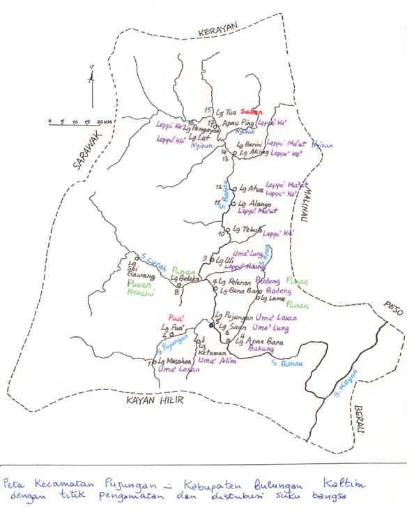
Pujungan District
|
Map drawn by Antonia Soriente whilst in the field, depicting one of her research areas around the Bahau & Pujungan Rivers, tributaries of the Kayan River in East Kalimantan. Click here for an indication of where this area is in East Kalimantan. |
 |
Last modified: 2002
Location: kenyah-maps-handdrawn.php.html